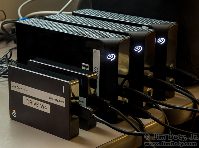
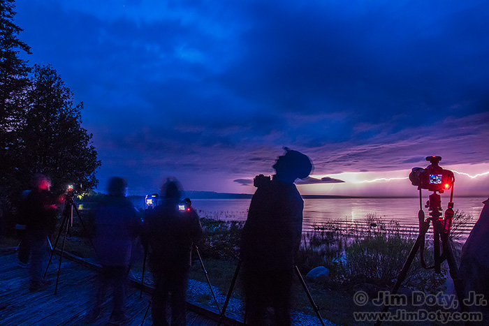
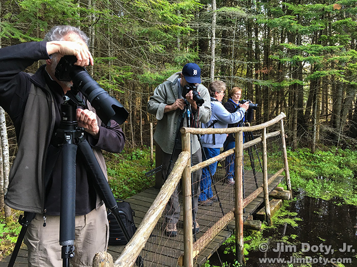
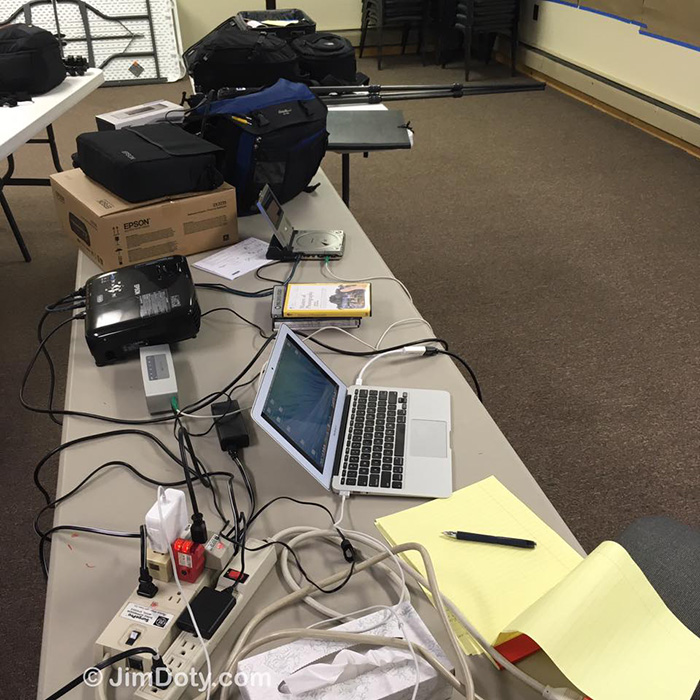
This is the grand prize winning photo.
Category Archives: General
The Met Makes 375,000 Works of Art Available in the Public Domain
That’s right, you can download works of art to your hearts content and use them any way you want from personal projects to commercial work for sale. If you want to put a photo of your great aunt Harriet in a Bierstadt painting and sell it on the internet, feel free.
Video: Every New York Times Front Page Since 1852
Every NYT front page since 1852 from Josh Begley on Vimeo.
The first front page photograph appeared in 1910 and the first color photograph in 1997.
Ansel Adams on Love, Friendship, and Art
1936 was a turning point in the life and career of Ansel Adams. It was also a time of emotional crisis.
Posted Feb. 25, 2017. Updated Dec. 14, 2017.
Create an Animated Gif Online, No Software Necessary
You can create an animated gif online without needing any special software on your computer. The site is GifCreator and it is free to use. Such a deal! I used it to create the above animated gif for an article I wrote a couple of days ago.
Ansel Adams: From Concert Pianist to America’s Best Known Landscape Photographer
Ansel Adams is arguably the best known American landscape photographer. Not so well known is that he was a talented and classically trained concert pianist. Were it not for some interesting and seemingly random events in his life he could have spent his life on the concert stage.
Posted Feb. 24, 2017. Updated Dec. 15, 2017.
It Is Not Too Late To Photograph Snowy Owls
It is not too late to photography Snowy Owls in the far northern United States.
A Sample of Ansel Adams Humor
You Can Play “Ansel Adams” with His Images in Your Digital Darkroom
Thanks to the U.S. National Archives, you to can work with Ansel Adams own negatives in your digital darkroom.
Download High Resolution Public Domain Images by Ansel Adams
The U.S. National Archives decided to make available over 200 of the high resolution public domain photos taken by Ansel Adams. You can download them here.
Video: Yosemite and the Range of Light by Ansel Adams
Ansel Adams: Yosemite and the Range of Light.
Marc Silber interviews Michael Adams, son of Ansel Adams, in Ansel’s home and workroom/darkroom. They discuss Adams’ book Yosemite and the Range of Light. “The Range of Light” is the phrase John Muir used to describe the Sierra Nevada. Some video footage of Ansel Adams is included. Watch and learn.
Books and Calendars from the Master: Ansel Adams
I have no idea when I was first entranced by the photos of Ansel Adams. There is a wonderful, luminous quality to his work. Small wonder he is America’s best known landscape photographer. Collections of his work would make a worthy addition to any photographer’s library. This is also the time of year that Ansel Adams calendars pop up like snowstorms.
Contrast in the Photography of Ansel Adams
Contrast is a matter of personal taste. A classic illustration of this is the way Ansel Adams interpreted his negatives when he made prints, and how that changed over time. Adams often said “The negative is similar to a musician’s score, and the print to the performance of that score.”
Video: Ansel Adams Printing in the Darkroom
THIS VIDEO IS NO LONGER AVAILABLE. I WILL TRY AND FIND IT AT ANOTHER LINK.
A classically trained musician, Ansel Adams thought of his negatives as the score and his work in the darkroom as the performance. He would “interpret” his negatives differently, “dodging” and “burning” during the printing process to create a more dramatic image. In this short video you get to watch the master at work.
Happy Birthday, Ansel Adams!

Ansel Adams in front of “Monolith: The Face of Half Dome, 1927”. Photographed in his home Dec. 2, 1980.
Ansel Adams was born February 20, 1902. He is “the” icon of American landscape photography. Trained as a concert pianist, his love of photography and time spent in Yosemite National Park led him to a career change.
Having Fun with Jeffrey Friedl’s Image Metadata Viewer
If you want to look at the metadata embedded in online photos, including GPS coordinates, this is an excellent online viewer. And it is simple. Just grab the URL for an online photo, drop it into the URL box on Jeffrey’s site, verify you aren’t a robot, and then check out the tons of metadata (check out the examples below). This is the most comprehensive metadata viewer I have found.
How to Process Aerial Photos with Your Favorite Image Editing Software
Thanks to atmospheric haze, aerial photos usually don’t look very good right out of the camera. The fastest, simplest, and best way to fix your aerial photos is with Adobe Camera Raw (ACR). If you don’t have ACR there are other good options in your favorite image editing software. They won’t be as fast but they will get the job done. This article shows you how.
How to Correct Exposures with a Levels Adjustment Layer
Levels is a powerful tool and relatively simple to learn. Levels provides a quick, simple, and effective way to correct basic exposure problems. This tutorial will show you how to adjust the exposure of your images with levels.
How to Process Aerial Photos with ACR
Photos from a commercial jet don’t look very good right out of the camera because you are seven miles off the ground. You are usually shooting through seven miles of atmospheric haze, even on a relatively clear day. If you are flying on a hazy day it is going to be even worse. Fortunately, you can save many of your aerial photos with a quick fix in Adobe Camera Raw (ACR).
Originally posted Feb. 12, 2017. Updated Feb. 17, 2017.
“How To” Series: Using GPS in Photography
The GPS system is increasingly important to photography. It will help you figure out where you took some of your more obscure photos and help you caption your photos. More and more photo editors want GPS information for the photos they publish. A GPS communicator could save your life. This series will help you learn the ins and outs of GPS, plus keep you and your family safe.
Originally posted Jan. 29, 2016. Updated and re-posted Feb. 11, 2017. Updated March 18, 2024.
Geotagged Photos: Posting Photos Online Can Put Your Family at Risk
Your smartphone is designed to geotag the locations of your photos and store it in the photo’s “metadata”. Many other cameras do the same thing. This means if you take pictures of your family and post them online, anyone (including some very unsavory characters) can pull up a map of where the photo was taken. Is there really a danger? Yes. Are you at high risk for this happening to you? That is hard to say. Is it better to be safe than sorry? Of course. What can you do to protect your family? Keep reading.
Originally posted August 13, 2013. Revised and updated and re-posted Feb. 11, 2017.
Satellite Communicators: The GPS Messaging Devices That Can Save Your Life
You need help. You can barely move. You are far enough from the trail that no one can hear your voice. You have no cell phone signal. What do you do?
Every now and then you hear tragic stories about people who lose their lives simply because they didn’t have a cell phone signal and couldn’t call for help in an unexpected emergency. A $260 – $340 satellite communicator would have saved their lives.
Originally posted Nov. 10, 2014. Updated and re-posted Feb. 11, 2017.
Geotagging Aerial Photos: The Joys and Frustrations of Using GPS on an Airplane
When I am taking pictures from an airplane I am curious where I am and what I am seeing down below. Sometimes it is obvious, like the Grand Canyon, and sometimes it isn’t. GPS on a plane should help a lot. At least that’s the theory.
How to Photograph Comet 45P

Comet Lovejoy. January 19, 2015. Cropped from a photo taken with a 24mm lens. Click for a larger version.
If you aren’t used to photographing faint objects in the night sky, this will be a challenge, but I suggest you try anyway. You have nothing to lose and a photo to gain.
Originally posted Feb. 9, 2017. Revised and expanded Feb. 10, 2017.
Using Google Earth in 3D Mode to Label Aerial Photos
Your friendly magazine photo editor wants to know if you have an aerial photo of Crestone Peak. Or maybe you are just curious about the stuff you photograph out an airplane window. Looking at a map, a topographic map, or a satellite image is the usual way to identify objects in an aerial photo, but sometimes that doesn’t work very well. That’s where Google Earth in 3D “flyover” mode comes in.
Originally posted Feb. 8, 2017. Updated Feb. 11, 2017.
How to Photograph from a Plane at Dusk (The Sangre de Cristo Mountains)
Everything but time was in my favor. I was able to grab a good window seat (well ahead of the engines) with a clean, un-crazed window on the correct (right) side of the plane to photograph the Sange de Cristo Mountains.
How To Get GPS Coordinates Into Google Earth

El Capitan in the moonlight along with a camera and tripod. El Capitan Meadow, Yosemite National Park, California.
GPS Data is increasingly important to photographers. It is the link between photos and photographic locations. It can be very helpful to drop GPS coordinates into a program like Google Earth to be able to tell exactly where a photo was taken. How do you do that?
Originally Feb. 9, 2016. Updated and re-posted Feb. 5, 2017.
Using Google Earth to Find the Name of a Mountain (and How to Get GPS Info into Google Earth)
What is the name of this mountain? Photo editors want to know. They like caption information. If you have a distinctive mountain in your photo, “Mountain in Colorado” won’t cut it with your friendly neighborhood photo editor. Here’s how to identify that mountain in Google Earth (and how to get GPS coordinates into Google Earth).
Originally posted Jan. 26, 2016. Updated and re-posted Feb. 5, 2017.
Checking the GPS Location Accuracy of Your Camera, Part Two
The fastest way to check location accuracy your camera’s GPS information is to take a photo at a known location that you can pinpoint on a map.
Posted Jan. 28, 2016. Updated and re-posted Feb. 3, 2017.
Checking the GPS Location Accuracy of Your Camera, Part One
In a prior article (on figuring out the name for Antora Peak) I noted the discrepancy between the GPS coordinates provided by my iPhone and the actual location where I took the photo (graphic above). They were off by about 20-30 feet. You can test the accuracy of the GPS information provided by your camera/smartphone. This article will show you how.
Originally posted Jan. 28, 2016. Updated and re-posted Feb. 3, 2017.