
One of the ways to answer that question is to look at hard drive failure rates from a company that uses over 100,000 hard drives.

One of the ways to answer that question is to look at hard drive failure rates from a company that uses over 100,000 hard drives.
 Welcome to my online buying guide for photographers. With over 70 articles it is one of the most comprehensive buyer’s guides on the web.
I get lots of photo questions, and many of them begin with “What is the best . . . .” They usually come from photographers or someone who is shopping for a photographer.
My “best of the best” series recommends the best photo gear, accessories, software, books, DVDs, online photo labs, and a whole lot more. Thanks to the information in these articles I get emails from photographers thanking me for saving them time, frustration, and a lot of money.
This article is published annually in November with regular updates. Most recent update: December 14, 2019.

Photoshop Masking and Compositing (2nd edition)
Two essential and challenging Photoshop skills are Masking and Compositing. Fortunately for all of us out in Photoshop land, Katrin Eismann (along with Sean Duggan and James Porto) have written a masterful book on developing these skills, Photoshop Masking & Compositing (2nd edition).

Adobe Photoshop Restoration and Retouching (4th edition)
Katrin Eismann is a world class expert on photo retouching. She is one of the best of the best. In 2005 she was inducted into the Photoshop Hall of Fame. Anything she writes should be high on your reading list if you are serious about making the most of your Photoshop skills.

Photoshop Lab Color (2nd edition)
Everything you need to know about Dan Margulis is in Mastering Photoshop: Advanced Color Correction, Part One. After you have devoured the book I recommend in that article, you will know why you need to get Photoshop LAB Color: The Canyon Conundrum and Other Adventures in the Most Powerful Colorspace (2nd edition).
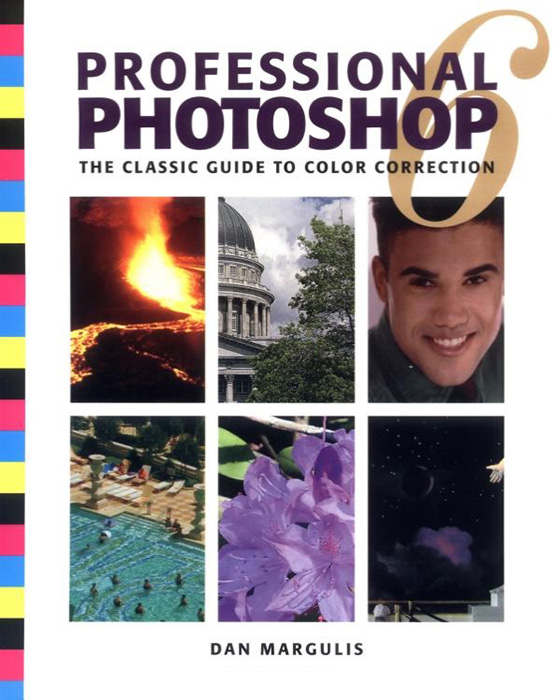 If you want to master color in Photoshop, Dan Margulis is the best of the best. He is one of the first three persons to be named as a member of the Photoshop Hall of Fame. And the book to get is Professional Photoshop 6: The Classic Guide to Color Correction. It is well worth finding on the used market (which you can do via my photography store). What Margulis teaches you to do with color is amazing. The before and after images will make your jaw drop.

The Digital Negative, 2nd edition
If you shoot RAW camera files (and you should), this essential book should be at the top of your list. It is far and away the best of the best. You will be amazed at what you can get out of your RAW files. Your images will thank you.
A lot of the quality of your final image will be determined by what you do with your RAW files when you open them in Adobe Camera RAW (ACR) which comes with Adobe Photoshop, Adobe Photoshop Elements, and Adobe Lightroom.
If you want to master Photoshop, a complete course can be found in the books recommended below. Think of this as a multi-book master class.

Lightroom & Photoshop: The Essentials
If you are serious about digital photography and you use Lightroom and/or Photoshop, these books are “The Essentials”. These are the books you read when you are ready to move beyond the basics.
 Scott Kelby has written some of the best, most readable introductions to Elements, Lightroom, and Photoshop. If you are new to this software, this is a great place to start.

Your photos will look their very best if you optimize them with high quality image editing software.
Welcome to my online buying guide for photographers. With over 70 articles it is one of the most comprehensive buyer’s guides on the web.
I get lots of photo questions, and many of them begin with “What is the best . . . .” They usually come from photographers or someone who is shopping for a photographer.
My “best of the best” series recommends the best photo gear, accessories, software, books, DVDs, online photo labs, and a whole lot more. Thanks to the information in these articles I get emails from photographers thanking me for saving them time, frustration, and a lot of money.
This article is published annually in November with regular updates. Most recent update: May 8, 2020.
You are on a road you have never been on before. You to stop to take a picture which includes a prominent mountain. How do you find out its name?
I was photographing baby sparrows being fed in a bird house. The depth of field (DOF) was really shallow and I was curious how shallow.

Christmas Lights, Easton Shopping Center, Columbus, OH
‘Tis the season and there are a lot of Christmas lights out there to photograph. It is fun and easy, and with a few tricks up your sleeve there are creative things you can do. Many of these techniques can be used on other lights throughout the year, so this is a good time to practice your skills for photographing lights.
Photoshop Masking and Compositing (2nd edition)
Two essential and challenging Photoshop skills are Masking and Compositing. Fortunately for all of us out in Photoshop land, Katrin Eismann (along with Sean Duggan and James Porto) have written a masterful book on developing these skills, Photoshop Masking & Compositing (2nd edition).
Adobe Photoshop Restoration and Retouching (4th edition)
Katrin Eismann is a world class expert on photo retouching. She is one of the best of the best. In 2005 she was inducted into the Photoshop Hall of Fame. Anything she writes should be high on your reading list if you are serious about making the most of your Photoshop skills.
Photoshop Lab Color (2nd edition)
Everything you need to know about Dan Margulis is in Mastering Photoshop: Advanced Color Correction, Part One. After you have devoured the book I recommend in that article, you will know why you need to get Photoshop LAB Color: The Canyon Conundrum and Other Adventures in the Most Powerful Colorspace (2nd edition).
If you want to master color in Photoshop, Dan Margulis is the best of the best. He is one of the first three persons to be named as a member of the Photoshop Hall of Fame. And the book to get is Professional Photoshop 6: The Classic Guide to Color Correction. It is well worth finding on the used market (which you can do via my photography store). What Margulis teaches you to do with color is amazing. The before and after images will make your jaw drop.
The Digital Negative, 2nd edition
If you shoot RAW camera files (and you should), this essential book should be at the top of your list. It is far and away the best of the best. You will be amazed at what you can get out of your RAW files. Your images will thank you.
A lot of the quality of your final image will be determined by what you do with your RAW files when you open them in Adobe Camera RAW (ACR) which comes with Adobe Photoshop, Adobe Photoshop Elements, and Adobe Lightroom.
 If you want to master Photoshop, a complete course can be found in the books recommended below. Think of this as a multi-book master class.
Lightroom & Photoshop: The Essentials
If you are serious about digital photography and you use Lightroom and/or Photoshop, these books are “The Essentials”. These are the books you read when you are ready to move beyond th3e basics.
Your photos will look their very best if you optimize them with high quality image editing software.

My grandson inside using my laptop to control the tripod mounted camera outside.
CamRanger provides wireless image transfer from your camera to your laptop or smartphone. CamRanger also give you wireless control of your camera with your smart phone or laptop.
Welcome to my online buying guide for photographers. With over 70 articles it is one of the most comprehensive buying guides on the web.
I get lots of photo questions, and many of them begin with “What is the best . . . .” They usually come from photographers or someone who is shopping for a photographer.
My “best of the best” of articles recommends the best photo gear, accessories, software, books, DVDs, online photo labs, and a whole lot more.
This article is published annually in November with regular updates in November and December. Most recent update: December 30, 2018.
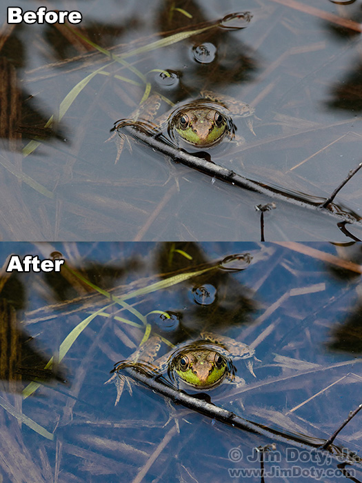
Green frog, before and after.
Are your best images worth two minutes of your time? If they are, two of the best things you can do for the quality of your images is to shoot RAW files and process the images with Adobe Camera Raw (ACR).
 One of the secrets to great color is to set you camera to bland. That might sound odd, but it is what you do to end up with great color. Your images will thank you.

O’Haver Lake, Mt. Ouray, Colorado.
You have heard it said a lot, and maybe said it yourself: “This picture doesn’t do the scene justice.” That is often true and for several reasons. One is that digital cameras do not capture reality. No matter how fancy or expensive, digital cameras simply do not capture what your eyes see. That is also true with film cameras. All color photographic films have different color characteristics. Some have better reds, others have better greens or blues. Some are more saturated and others less saturated. But none of them are totally color realistic. So why don’t digital cameras give you realistic images and what can you do about it?
Originally posted December 16, 2015. Revised, expanded, and re-posted May 4, 2018. Updated October 31, 2018.

Setting a “Custom White Balance” at the beginning of a photo shoot will save you a lot of time. It will only take a minute or so and can save you a lot of work later on. Think how long it would take you to color correct 250 images.
Posted April 22, 2015. Revised and re-posted Jan. 5, 2018.
 Most digital cameras give you a choice of several pre-set white balance settings (daylight, tungsten, cloudy, shade, and others), but they won’t give you the most accurate white balance in a mixed lighting situation. If you choose a pre-set, the colors in your images will be off.