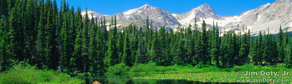

Mount Rundle, Two Jack Lake
Today (Mar 18, 2014) I was asked by a client where I was when I took some photos in Banff National Park. I was able to provide him with the exact locations, complete with marked satellite images. It is a good idea to known where you were when you created your most important images, and the more specific the information the better. It is good info to have for your own use and sometimes it can make the difference between whether or not one of your images is published.
Originally posted Mar. 18, 2014. Updated and re-posted Jan. 30, 2017.

Last Light on Mount Rundle (looking ESE from Vermilion Lakes 3)
If you don’t keep track of your favorite images now, years from now you may not remember where you took them. I have some spring wildflower photos that I remember taking somewhere in the Texas Hill Country. It is a big area and I don’t know exactly where I was when I created the images. I wish I did.
Another reason is for your family. I inherited some old black and white photos from my grandparents which include photos by their parents. Some of them are labeled on the back in pencil, but many of them aren’t. I really wish I knew where some of those photos were taken (and who some of the people are in the photos, but that is another story).
Some digital cameras record the GPS location in the metadata of your photos (turn this feature on in the camera’s menu system if you want to use it), so you are good to go. If your camera doesn’t record GPS information, there are some simple things you can do to keep track of your photo locations.

Sunset, Vermilion Lakes 3 (looking west). Note the wooden dock at right center.
One way is to have a photo trip log where you keep track of where you are, what you photograph, and when. At the end of a trip, photograph the pages of the log so they are with your photos from the trip. If you look at a photo taken at 8:55 am on April 25 and can’t remember which of several Bryce Canyon “viewpoints” you were at that morning at 8:55 (see the trip log photo in my linked article), you check your photo log and say, “Ah – I was at Inspiration Point from 8:50 to 10:27”. Just look up Inspiration Point on an online map of Bryce Canyon and you are good to go. If National Geographic asks if you have a morning photo from Inspiration Point, you are ready.
Another option before things fade from your memory is to bring up an online map of the locations where you took your photos, do a screen capture, and mark it with the locations of your most important photos. Save the labeled map/s with the photo/s. I try to do this during or shortly after a trip.

Map, photo locations at Two Jack Lake and Vermilion Lakes 3.
All three photos in this article were taken at Banff National Park. The morning image (Y) was created at Two Jack Lake. The two sunset photos (marked with an X in the map above and the satellite image below) were taken within five minutes of each other at Vermilion Lakes 3.

Vermilion Lakes 3, location for sunset photos.
The sunset photos were taken within a few feet of each other at the same turnout in the road. A small, wooden dock is just west of the turnout and you can see it in the second sunset photo above. I found a satellite photo online and marked my location with a red X. The turnout in the road and the dock to the west (a small white rectangle) are both clearly visible (click on the image to see a large version). If you do this in Google Earth, you can drop a pin at the location where you took your photo and Google Earth will give you the GPS coordinates. The coordinates will be approximate but you can get pretty close.

Camera location for photo of Mount Rundle and Two Jack Lake. iPhone photo #5777.
If you have a smart phone that records the GPS coordinates of your photos, just take a photo of the same scene with your camera phone from the same location as your primary camera location (or photograph your camera and the scene). In this case, I took a photo of the camera and tripod for the Mt. Rundle/Two Jack Lake photo. You can see the small foreground island that is in the photo at the top of this post. As you can see, to get the exact angle I wanted for the original photo, two tripod legs (one leg is hidden behind the other) and my left foot (you can see the foot print) were in the gravel where water lapped up to the lake shore. A wet foot on a cold morning is a small price to pay to get the photo you want.

GPS Tab of the File Info (metadata) for the iPhone photo (#5777) above.
When you download your smart phone images you can look at the GPS coordinates with your favorite image editing software. Photoshop Elements, Adobe Photoshop, and Adobe Lightroom are three examples of software that will do this (and there are many others). Just open the image, choose File > File Info, and look at the GPS tab in the pop-up window.

Camera location for photo of Mount Rundle from Two Jack Lake.
Drop the GPS coordinates into any of number of online mapping sites (including Google Maps and Google Earth), and you will have a map with a pin marking the location of your photo. Do a screen capture and label the image with image editing software. Save the image with the photo. If you look carefully at this satellite image, you can see the small island that is in the Mount Rundle/Two Jack Lake photo at the top of this article. It is the faint, small, narrow, semi-dark, diagonal streak in the yellow area (shallow water) just below and to the left of the red pin.
Do I do this with every image? Of course not. Too much time and effort and it would drive me crazy. But I do with my most important images. And if I’m not sure, I grab a photo from the same location with my iPhone. It just takes a few seconds and I will have access to the GPS data if I ever need it. If an editor wants to know where I took a photo, I pull up the iPhone photo from the same location, look up the GPS data and drop it into a map.

Another Two Jack Lake i Phone photo (#5788) from a slightly different location along with the GPS Data.
The next time someone wants to know exactly where you took a photo, you will be ready!
Link
GPS Series Links
“How To” Series: Using GPS in Photography – An Overview
“Where Were You When You Took Those Photos?”
The Why and How of Adding GPS Information To Your Photos
How To Get GPS Coordinates Into Google Earth
Checking the GPS Location Accuracy of Your Camera, Part One
Checking the GPS Location Accuracy of Your Camera, Part Two
Comparing the GPS Accuracy of Three Cameras
Using Google Earth to Find the Name of a Mountain (and How to Get GPS Info Into Google Earth)
Geotagging Aerial Photos: The Joys and Frustrations of Using GPS on an Airplane
Using Google Earth in 3D Mode to Label Aerial Photos
Satellite Communicators: The GPS Messaging Devices That Can Save Your Life
Geotagged Photos: Posting Photos Online Can Put Your Family at Risk