
Last Light on Mount Rundle
This is a lesson in patience. Most photographers missed this sunset. I was on location four separate evenings hoping to capture stunning sunset light on Mount Rundle. It only happened once. It also helps to know where to be, when, and how to meter in high contrast lighting situations.
Over a week’s time I picked four evenings to be at the Vermilion Lakes in time for sunset. My favorite location was Vermilion Lakes 3, but you might prefer 1 or 2. Almost at the end of the road (past lake 3) is a small sheltered pond that is more likely to have still water for reflections at sunset. The Vermilion Lakes Scenic Drive is only 4.2 km long so it is easy to drive up and down the road and pick a spot to your liking. The turn off to the scenic drive is on Norquay Drive just south of the intersection with the Trans Canada Highway (Highway 1). The scenic drive parallels the Trans Canada Highway. This partial screen capture from my iPhone shows the Town of Banff and the blue dot marks the location at Vermilion Lakes 3.

Vermilion Lakes 3
For more locations, check out the excellent Banff photography eBook in the “Links” section below.
Day 1 and Day 2, the sunset light on Mount Rundle was only average. The sky was mostly clear both days, not enough clouds to create a beautiful sunset. The photographers were lined up tripod to tripod. It was hard to find a place to set up without being in the way of or behind someone else. Everyone was being quite courteous. The sunsets both days were “nice” and everyone seemed pleased, but the light was certainly not out of the ordinary.
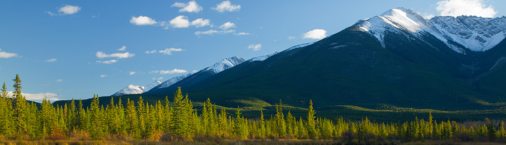
The evening of Day 3 was cloudy, overcast, gloomy, drizzly, and chilly. The kind of day you are tempted to stay inside by the fire and read a good photography book. I debated whether or not to head out or stay in and decided to go. Some of the cloudiest days can end up providing the most spectacular sunsets (not always, or even often, but sometimes). Out at the lakes a few photographers came and went, but most of them had gone home before the light show really began. It was past time for the sun to set, if we could see the sun, but it was hidden behind clouds as it dropped behind the western mountains (see The Photographer’s Ephemeris in the Links section below).
Waiting for something to happen, a faint glow began to paint Mount Rundle. Somewhere out of sight below the western peaks the clouds began to part. The band of light climbed the western flanks of Mount Rundle, growing narrower and more intense by the minute. As the light was just kissing the upper edges of the mountain, the light was at it’s best.
Only one other photographer was around for the whole light show. He said it was the best sunset he has seen since moving to the nearby town of Banff a year and a half ago.
Metering was critical. A camera in auto-exposure mode would meter the much larger, darker surface of the mountain side and make it a medium tone, washing out the rim of sunlight on the upper flanks of the mountain. In manual mode, I metered just the narrow sunlit area and made that a medium tone to insure the color intensity of that part of the scene, letting the rest of the scene go dark.
For an example of how a camera’s autexposure system gets it wrong when the middle of a scene is dark, look at the pair of “Long’s Peak and Nymph Lake” photos in the middle of this article on reflected light metering.
What about Day 4? Gray, cloudy, gloomy and drizzling. I was on location again but Mount Rundle was completely hidden by the clouds.
Exposure Data: Canon 7D. Canon EF 70-200mm f/4 lens set at 70mm (for an effective focal length of 112mm on a full frame camera). Aperture: f/4, shutter: 1/50 second, ISO 100.
Links
For more information on metering, working with the best light, and landscape photography, read Digital Photography Exposure for Dummies. You can learn more here and buy it at Amazon.com.
Banff National Park – The official site of Parks Canada.
Banff National Park by Darwin Wiggett – The best guide to photo locations in Banff National Park. It is a $10 (CAD) downloadable eBook. It was a better guide to locations than any other source I could find. Darwin also has guides to other National Parks in Canada.
The Photographer’s Ephemeris – the best computer software and iPhone app for determining where and when the sun will rise and set at the location of your choice on the dates of your choosing. You can save your favorite locations for instant reference. For the best maps on The Photographer’s Ephemeris (“TPE”), I recommend you DO NOT UPGRADE to iOS6. TPE uses whatever mapping program you have on your iPhone. The Apple Maps that comes with IOS6 are pathetic in comparison to Google Maps which came with prior versions of iOS. Apple Maps is so bad that Tim Cook issued an apology for Apple Maps.
Two Bed and Breakfasts I recommend if you stay in the Town of Banff:
At Wit’s End B&B – At Wit’s End is smaller, more like staying in a home, and more flexible in terms of time. The owner got up before 6 am to make sure I had a hot breakfast before I left early to chase sunrises. And she left a fresh fruit and yogurt parfait in the fridge. Cereal, fruit, and muffins are out all the time. Juice is always in the fridge. Tell April and Peter I sent you!
Banff Boutique B&BÂ – Banff Boutique is bigger and fancier, more like a hotel, but breakfast was set at 8:00 – 9:30 am. If you head out early to take pictures, there are fix-in’s for cereal and bread on your own.
Hospitality was excellent at both places.